
Jennifer Reynolds/The Galveston County Daily News via AP
In Haiti and the Dominican Republic, 23 people have died as a result of Laura, which was then a tropical storm.
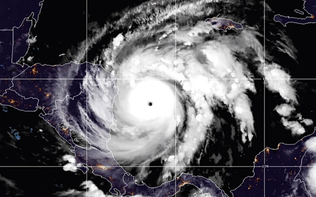
The National Hurricane Center (NHC) reports that Laura has strengthened overnight and is now a hurricane in the southeastern Gulf of Mexico. Projections show that Laura—which was a tropical storm when it hit Cuba—will keep gaining strength and is poised to become a major hurricane as it makes its way to Texas and Louisiana.
READ MORE: We Break Down the Dos and Don’ts of Voting by Mail in Florida
The National Oceanic and Atmospheric Administration (NOAA) projects that Hurricane Laura will enter the Gulf Coast this evening by 8 p.m. and make landfall as early as Wednesday, but more likely in the evening. The agency added that it could bring a storm surge of 7 to 11 feet along portions of the coast. However, the biggest threat and impacts from Laura are “going to occur well outside of the cone,” said Ken Graham, director of the National Hurricane Center.
“This cone is like a warning flare to all those who live around the storm’s potential track that you’re not in the clear just because this forecast doesn’t aim the storm directly at you,” weather expert Dennis Mersereau wrote, calling it a “cone of uncertainty.”
As of Tuesday morning, the NOAA reports that Hurricane Laura had maximum sustained winds of 75 mph, and the center of the storm was located 625 miles from Lake Charles, Louisiana. Hurricane Laura has already caused fatalities, killing 23 people in Haiti and the Dominican Republic.
The latest advisory by the NOAA warns of risk of life-threatening storm surge from San Luis Pass, Texas to Ocean Springs, Mississippi within the next 48 hours. It also reports a threat of widespread flash and urban flooding, along with small streams overflowing their banks, from far eastern Texas, across Louisiana and Arkansas on Wednesday and Thursday. Areas of middle-Mississippi, lower Ohio, and Tennessee Valley could see heavy rainfall on Friday and Saturday. Coastal areas in Louisiana and Texas have already issued evacuation orders.
“Property and belongings can be restored, but lives cannot,” Texas Gov. Greg Abbott said in a statement on Monday. “I call on all Texans who may be in harm’s way to put their safety and their family’s lives above all else.”
Yesterday, the Cameron Parish Office of Emergency Preparedness in Louisiana issued a mandatory evacuation of the parish in anticipation of the dual storms in the Gulf of Mexico.
READ MORE: Joe Biden Has Released His Healthcare Plan. Here’s What It Means for You.
“We also advise residents of Cameron Parish who live in an area not listed, that are prone to flooding, to also take all preliminary precautions and finalize their evacuation preparation plans at this time due to Tropical System Laura,” stated Cameron Parish officials. “Driving conditions are expected to remain favorable until mid-day on Wednesday, August 26, 2020. Campers/travel trailers should also be removed from the areas of evacuation.”
One piece of good news is that Tropical Storm Marco, that was coinciding with Hurricane Laura in the same area, has now decreased in strength. However, Marco may still cause a storm surge for parts of Louisiana and Mississippi.
Author
Politics

Teamsters and UPS Reach Tentative Deal to Avoid Strike, 340,000 Workers to Get Raises
The tentative deal represents a huge win for full- and part-time UPS Teamster workers, who would get significant pay raises and better working...

One Republican Senator Is Blocking 265 Military Promotions, Leaving the Marines Without a Confirmed Leader
Sen. Tommy Tuberville's decision means these military officers are not getting the pay raises they’re owed, cannot move their families to wherever...
Local News
Teamsters and UPS Reach Tentative Deal to Avoid Strike, 340,000 Workers to Get Raises
The tentative deal represents a huge win for full- and part-time UPS Teamster workers, who would get significant pay raises and better working...
One Republican Senator Is Blocking 265 Military Promotions, Leaving the Marines Without a Confirmed Leader
Sen. Tommy Tuberville's decision means these military officers are not getting the pay raises they’re owed, cannot move their families to wherever...

