Image via AP Photo/David J. Phillip
Evacuating amid a pandemic is also making the situation much more chaotic.
Hurricane Laura is forecast to rapidly power up into a “catastrophic” Category 4 hurricane, even stronger than previously expected, as it churns toward Texas and Louisiana, swirling wind and water over much of the Gulf of Mexico.
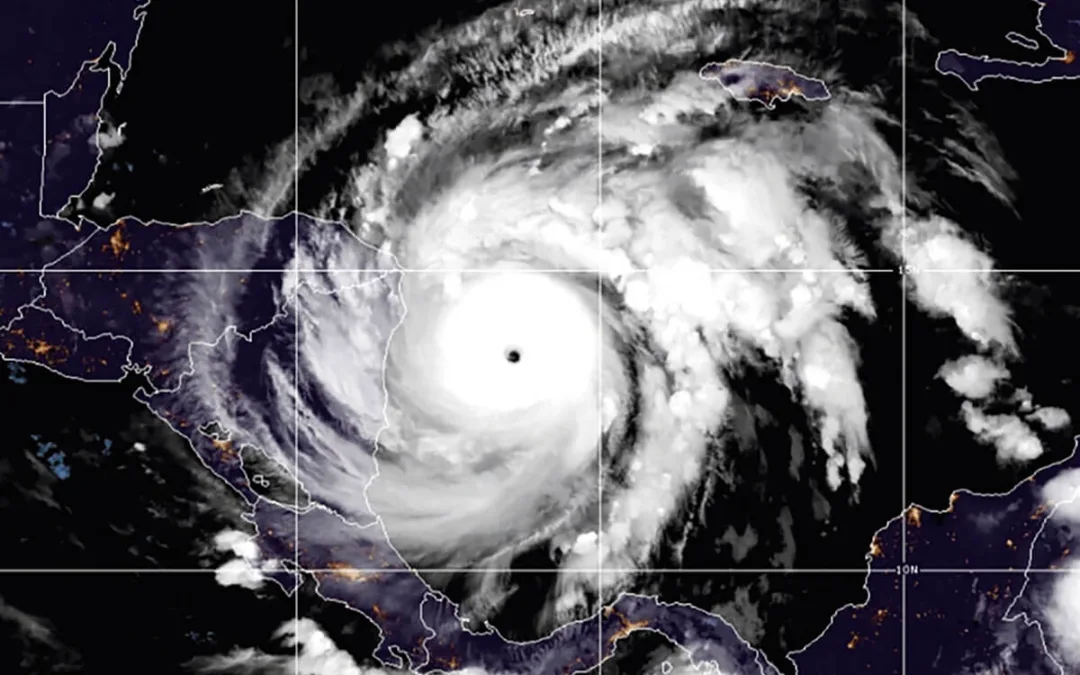
Satellite images show Laura has become “a formidable hurricane” in recent hours, threatening to smash homes and sink entire communities. It has undergone a remarkable intensification, “and there are no signs it will stop soon,” the National Hurricane Center said early Wednesday.
Laura grew nearly 70% in power in just 24 hours to reach Category 3 status, with maximum sustained winds around 115 mph (185 kph) on Wednesday morning. It was about 280 miles (450 kilometers) out of Lake Charles, Louisiana, moving northwest at 15 mph (24 kph).
Top winds of 130 mph (209 kmh) are now predicted before landfall, pushing water onto more than 450 miles (724 kilometers) of coast from Texas to Mississippi. Hurricane warnings were issued from San Luis Pass, Texas, to Intracoastal City, Louisiana, and storm surge warnings from the Port Arthur, Texas, flood protection system to the mouth of the Mississippi River.
A Category 4 hurricane will do catastrophic damage: “Power outages will last weeks to possibly months. Most of the area will be uninhabitable for weeks or months,” the weather service says.
In the largest U.S. evacuation of the pandemic, more than half a million people were ordered Tuesday to flee from an area of the Gulf Coast along the Texas-Louisiana state line.
More than 385,000 residents were told to evacuate the Texas cities of Beaumont, Galveston and Port Arthur. Another 200,000 were ordered to leave the low-lying Calcasieu and Cameron parishes in southwestern Louisiana, where forecasters said as much as 13 feet (4 meters) of storm surge topped by waves could submerge whole communities.
In Galveston and Port Arthur, Texas, many people boarded buses to Austin and other inland cities. “If you decide to stay, you’re staying on your own,” Port Arthur Mayor Thurman Bartie said.
Laura also is expected to dump massive rainfall over a short period of time as it moves inland, causing widespread flash flooding in states far from the coast. Flash flood watches were issued for much of Arkansas, and forecasters said heavy rainfall could move to parts of Missouri, Tennessee and Kentucky late Friday and Saturday.
Officials urged people to stay with relatives or in hotel rooms to avoid spreading the virus that causes COVID-19. Buses were stocked with protective equipment and disinfectant, and they would carry fewer passengers to keep people apart, Texas officials said.
Whitney Frazier, 29, of Beaumont spent Tuesday morning trying to get transportation to a high school where she could board a bus to leave the area.
“Especially with everything with COVID going on already on top of a mandatory evacuation, it’s very stressful,” Frazier said.
Shelters opened with cots set farther apart to curb coronavirus infections. Evacuees were told to bring a mask and just one bag of personal belongings each.
“Hopefully it’s not that threatening to people, to lives, because people are hesitant to go anywhere due to COVID,” Robert Duffy said as he placed sandbags around his home in Morgan City, Louisiana. “Nobody wants to sleep on a gym floor with 200 other people. It’s kind of hard to do social distancing.”
Author
Politics

Teamsters and UPS Reach Tentative Deal to Avoid Strike, 340,000 Workers to Get Raises
The tentative deal represents a huge win for full- and part-time UPS Teamster workers, who would get significant pay raises and better working...

One Republican Senator Is Blocking 265 Military Promotions, Leaving the Marines Without a Confirmed Leader
Sen. Tommy Tuberville's decision means these military officers are not getting the pay raises they’re owed, cannot move their families to wherever...
Local News
Teamsters and UPS Reach Tentative Deal to Avoid Strike, 340,000 Workers to Get Raises
The tentative deal represents a huge win for full- and part-time UPS Teamster workers, who would get significant pay raises and better working...
One Republican Senator Is Blocking 265 Military Promotions, Leaving the Marines Without a Confirmed Leader
Sen. Tommy Tuberville's decision means these military officers are not getting the pay raises they’re owed, cannot move their families to wherever...